
 We always knew that California was culturally separate from the rest of the U.S. and for a little over a hundred years in the 17th Century it was geographically separate too.
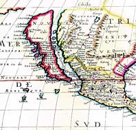
Anyway, I was looking for some images of the “Isla California” map today and discovered that not only are there a lot of different variations of the map – it’s also a popular subcategory for map collectors.
Some fun facts cribbed from the PRigsbee site…
The “California as an island” map originated in 1625 when British cartographer Henry Briggs used reports from Spanish sailors that had mistakenly combined the Gulf of California and San Francisco Bay. Briggs’ map was picked up by Dutch and then German mapmakers who in their hurry to crank out new maps perpetuated the mistake which continued until 1747 when King Ferdinand VII of Spain declared that California was not an island.
Which leads to a question: Is that decree on display in the Spanish archives somewhere? I’d love to see it.
As for the future, there’s always the complete meltdown of the polar caps, but until then we’ve got that John Carpenter movie to hold us.